position dilution of precision
- position dilution of precision
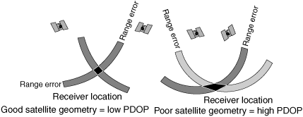
The geometric effect resulting from satellites being too close together. Satellites that appear farther apart in the sky provide a more accurate position solution than ones close together. In the latter case, the position accuracy is degraded in a similar fashion to when position lines from ground-based NAVAIDs (navigational aids) are less than 45°. Since the ephemeris of each satellite is known by the GPS (global positioning system) receiver, it is possible to calculate which combination of GPS satellites provides the best geometry at a given time. This is translated into a figure called the position dilution of precision (PDOP). Since the satellites move across the sky relative to the user, the PDOP is always changing. A low PDOP is better. A PDOP of 4 to 6 is considered good. Position solutions calculated when the PDOP is from 6 to 10 should be used cautiously because they may have significant error. A PDOP that is above 10 indicates unacceptable error. The ICAO (International Civil Aviation Organization) states that a PDOP of less than 6 is required for en route navigation, with a PDOP of 3 or less required for nonprecision approaches [i.e., not ILS (instrument landing system) types]. The geometric dilution of precision (GDOP) is the same as the PDOP, except that it includes a factor to account for any errors in the time.
Aviation dictionary.
2014.
Look at other dictionaries:
Dilution of Precision — (DOP), zu deutsch etwa Verringerung der Genauigkeit, ist bei Satellitennavigationssystemen ein Maß für die Streubreite der Messwerte. Da DOP von der relativen Position der Satelliten zueinander und zum Beobachter abhängt, spricht man auch von… … Deutsch Wikipedia
Dilution of precision (GPS) — This article pertains to the Global Positioning System. For the connotation pertaining to computer graphics, see dilution of precision (computer graphics). Dilution of precision (DOP), or geometric dilution of precision (GDOP), is a term used in… … Wikipedia
Global Dilution Of Precision — Le GPS (Global positioning system) s appuie, pour déterminer une position sur terre sur un principe de triangulation en regroupant les résultats de plusieurs satellites. En général trois satellites suffisent pour déterminer une position par ce… … Wikipédia en Français
Global dilution of precision — Un Système de positionnement par satellites (comme le GPS et le GLONASS) s appuie, pour déterminer une position sur terre sur un principe de triangulation en regroupant les résultats de plusieurs satellites. En général trois satellites suffisent… … Wikipédia en Français
PDOP — position dilution of precision … Military dictionary
PDOP — Position Dilution of Precision Contributor: CASI … NASA Acronyms
Abkürzungen/Luftfahrt/B–D — Dies ist der zweite Teil der Liste Abkürzungen/Luftfahrt. Liste der Abkürzungen Teil 1 A A Teil 2 B–D B (BA, BB, BC, BD, BE, BF, BG, BH, BI, BJ, BK, BL … Deutsch Wikipedia
геометрический фактор ухудшения точности по вектору положения — 2.15 геометрический фактор ухудшения точности по вектору положения (Position Dilution of Precision): Отношение трехмерной погрешности определения местоопределения в точке нахождения навигационной аппаратуры потребителя к погрешности измерения… … Словарь-справочник терминов нормативно-технической документации
ГОСТ Р 52865-2009: Глобальная навигационная спутниковая система. Параметры радионавигационного поля. Технические требования и методы испытаний — Терминология ГОСТ Р 52865 2009: Глобальная навигационная спутниковая система. Параметры радионавигационного поля. Технические требования и методы испытаний оригинал документа: 2.15 геометрический фактор ухудшения точности по вектору положения… … Словарь-справочник терминов нормативно-технической документации
Aerofotogrametría — La aerofotogrametría es la ciencia que permite obtener y/o realizar medidas correctas en base a fotografías aéreas, a fin de determinar las características métricas y geométricas de los objetos fotografiados desde un objeto volador (ya sea… … Wikipedia Español